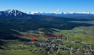
SHORT HIKES AROUND PHILIPSBURG
-
 by Craig Hergert
- April 2, 2026
- Blog
- 0
Contents:
-
Boulder Lakes Trail #33 (near Maxville)
-
Racetrack Lake Forest Road #242 (near Georgetown lake)
-
Stony Lake Trail #2 (near Rock Creek)
-
Fuse Lake Trail #12 (Off Skalkaho-Hwy 38)
-
Carpp Lake Trail #110 (In the Anaconda Pintler Wilderness, near East Fork)
-
Falls Fork Trail #29 Johnson & Edith Lakes (In the Anaconda Pintler Wilderness near Moose Lake)
-
Signal Rock Trail (Off Skalkaho-Hwy 38, near Sand Basin)
-
Medicine Lake Trail #15 (Off Skalkaho, Hwy 38, near Sand Basin)
-
Ivanhoe Lake Trail #27 (In the Anaconda Pinter Wilderness, near Moose Lake
-
Storm Lake to Goat Flats Trail #41 (in the Anaconda Pintler Wilderness, near Georgetown Lake)
——
-
BOULDER LAKES TRAIL #33
LENGTH: 4.6 miles one way
DIFFICULTY: More difficult. Suitable for hiking and equestrian use, some muddy spots & stream crossings, some rocky areas and steep pitches.
NARRATIVE: This trail is most often utilized by anglers on day hikes. The trail passes through mature stands of timber for most of its length, but there are a few overlooks of Powel Mine area from the last ridge before the lakes. There are actually two Boulder Lakes. Lower Boulder Lake is 9 acres and is 7,520 feet high. Trail #33 ends at the junction of the Dora Thorn Ridge Trail #37. Both lakes contain Western and Yellowstone Cutthroat trout. The lower lake offers slower fishing for larger fish, while Upper Boulder contains numerous smaller fish just for the frying pan.
ACCESS: This trail is accessed from the town of Maxville on Highway 1, The Pintler Scenic Route.
From Maxville, travel 8.8 miles up Forest Road #676 to the Boulder Lakes trailhead sign. It is accessible by high clearance vehicles through the summer and early autumn months.
PARKING & CAMPING: Parking is very limited, with only pull-offs in the woods, and there is room for only 405 vehicles. There is no room for a trailer to turn-around. There is no camping at the trailhead, but there are nearby undeveloped sites along the road and by the creek below the trailhead.
MAPS: USGS Quadrangle Pozega Lakes, MT
USGS Quadrangle Fred Burr, MT
-
RACETRACK LAKE FOREST ROAD #242
LENGTH: 9 miles
DIFFICULTY: Easy. The last four miles of the road are not suitable for passenger cars, and should be accessed only with high clearance 4 x 4’s, ATV’s or on foot or horseback. Hiking this section is relatively easy.
NARRATIVE: The road begins not far from Cable Campground. At first, the road is in good shape; wide well graveled, and smooth. There are some private in-holdings within the forest on the way up the road…remember, no trespassing. These in-holdings are old mines, some abandoned an some still active, that have colorful names from the area’s gold mining past – Golden Eagle, Golden Jubilee, and Red Lion. Near the five mile mark, the road starts to become much rougher and unsuited for passenger vehicles. At approximately 4.8 miles, one or two vehicles can park near some old log cabins, for those who wish to hike to the lake. Racetrack is a deep 35 acre lake at 7,640 feet, stocked with rainbow trout. From the dam at Racetrack Lake, Little Racetrack trail #62 leads southeast through the woods for ½ mile to Little Racetrack Lake, a small 6 acre body of water with fishing for rainbow/cutthroat cross. One more mile on this trail then leads to Fisher Lake, a 31 acre lake with Yellowstone Cutthroat Trout.
ACCESS: From Montana Hwy 1 (Pintler Scenic Loop) at Georgetown Lake, turn off on Forest Road #65 (Discovery ski Area. After 2.5 miles, Forest Road #242 leads off to the right. Cable Campground is located approximately a half mile down this road. Across from the campground is a large abandoned gravel pit that is now a roomy parking area for vehicles and ATV, stock or snowmobile trailers.
PARKING AND CAMPING: There is parking for 4x4s and ATVs around Racetrack Lake. A few low clearance vehicles can park at approximately the 4.8 mile mark. Cable Campground is a developed site at the beginning of the road with outhouses, picnic tables, fire grates, and drinking water. There are also undeveloped campsites around the mountain lakes.
MAPS: USGS Quadrangle Fred Burr Lake, MT
STONY LAKE – TRAIL #2
LA
LENGTH: 4 miles
DIFFICULTY: More difficult. Suitable for hiking & equestrian use, open to snowmobiles in the winter. This is an old jeep trail so conditions are relatively good but it is still considered difficult as there are numerous stream crossings and boggy areas as well as some steep areas.
NARRATIVE: This trail is most often utilized by anglers on day hikes. The trail follows the Stony Creek drainage up through lodgepole, spruce, and subalpine fir. At the end near the lake there are a few scenic overlooks, and a climb to the top of the ridge overlooking the lake offers great views. Stony is a 12 acre lake at 7,100 feet elevation that offers good fishing for cutthroat trout.
Past and above the lake Trail #2 ends where it intersects and joins the Bitterroot Device Trail #313.
ACCESS: From Philipsburg, travel just under 14 miles west on Highway 348 to the junction of Rock Creek Road #102 at Borhnsen Bridge. Go west 4.65 miles west on Rock Creek Road to Forest Road #241 and proceed up #241 5.6 miles to the trailhead. High clearance vehicles are recommended for that last portion of the road.
PARKING & CAMPING: Parking is available for a number of vehicles. There is no camping at the trailhead, but there are undeveloped sites along Stony and at Stony Lake itself.
MAPS: USGS Quadrangle Stony Creek, M
Note: This lake can also be accessed via Trail # 8010 off Skalkaho Hwy 38.
FUSE LAKE TRAIL #12
LENGTH: 2.6 miles
DIFFICULTY: The trail is suitable for hiking and stock use. It starts on an old reclaimed logging road, then winds through stands of lodgepole and winds up in whitebark pine. Fuse Lake lies at the end of the trail, at 7678 feet elevation, surrounded by rocky cliffs on three sides. Relatively deep and 13 acres in size, Fuse Lake offers the only fishing for grayling in the area. Below the lake, Trail #12 ends where it intersects Basin Gulch Trail #11.
ACCESS: From Philipsburg, MT drive approximately 6 miles south towards Anaconda on
Montana Hwy 1 (Pintler Scenic Loop) to its junction with the Skalkaho Hwy 38. Turn right on Hwy 38 and travel west to where the pavement ends near the Gem Mountain Mine. Beyond this point, the road is unsuited for long trailers or large RVs. Approximately 25 miles from the Hwy 38/Hwy 1 junction, near the top of the Skaikaho Pass, the Fuse Lake trailhead lies on the right side of the road. Watch for Trail #12 sign.
PARKING AND CAMPING: There is a nice parking area at the trailhead just off the Skalkaho Road, with room for trailers. There is no camping at the trailhead, but there are undeveloped sites at the lake. One and half miles further up the Skalkaho Hwy there is Crystal Park Campground, which offers picnic tables and a pit toilet.
MAPS: USGS Quadrangle Mount Emerine, MT
CARPP LAKE TRAIL #110
LENGTH: 3 miles
DIFFICULTY: More difficult. This is a hiking and equestrian trail. The trail gains a great deal of elevation rather quickly. Due to snowpack at high elevations, this route may not be accessible until June.
NARRATIVE: Don’t forget to sign in at the trailhead registration box. After leaving the parking area, the trail crosses Carpp Creek Trail #24 at the wilderness boundary. The path to Carpp turns right here. After approximately one mile, the trail begins its steep ascent through thick timber. About 2.7 miles from the trailhead, the trail reaches small, shallow, and marshy Lower Carpp Lake. It is approximately another quarter mile to 27 acre Carpp Lake, overlooked by towering 10,460 foot Warren Peak. Carpp Lake itself is at 7,797 feet elevation and offers fishing for Westslope Cutthroat Trout. Just past the lake the trail intersects the Hiline Trail #111, where a left turn leads to Warren Pass and a right turn climbs a ridge and then drops down into Tamarack Creek drainage. There are special regulations in effect for traveling and camping in the wilderness.
ACCESS: From Philipsburg, drive approximately 6 miles south towards Anaconda on Montana Hwy 1 (Pintler Scenic Loop) to its junction with the Skalkaho Hwy 38. Turn right on Hwy 38 and travel west for approximately five miles to a left turn on East Fork Road/ Forest Service Road
672. It is seven miles to East Fork Reservoir, where there are two campgrounds. Cross the dam and take Forest Service Road #5141 for another 16 miles from the reservoir to the end of the road.
PARKING & CAMPING: There is a large parking area at the end of the road, suitable for horse trailers as well as cars, with plenty of parking spaces for numerous vehicles. As notes, there are two developed campgrounds at East Fork Reservoir. When traveling and camping within the Anaconda-Pintler Wilderness itself please be aware there are some special regulations in effect to protect the resources. Please check these regulations at the ranger station in Philipsburg or the trailhead information boards.
MAPS: USFS Anaconda-Pintler Wilderness
USGS Quadrangle Carpp Ridge, MT
FALLS FORK TRAIL #29 JOHNSON & EDITH LAKES
LENGTH: 5 miles
DIFFICULTY: More difficult. This is a hiking and equestrian trail. There is a stream crossing as well as some switchbacks, steep pitches, and rocky scree areas.
NARRATIVE: Don’t forget to sign in at the trailhead registration box. After leaving the parking area, the trail crosses the Middle Fork of Rock Creek on a stock bridge and then enters the Anaconda-Pintler Wilderness as it climbs along the Falls Fork of Rock Creek drainage through stands of timber that include lodgepole pine and Douglas fir. There is a small waterfall along this route. After 3.3 miles, Falls Fork Trail merges with the Hiline Trail #111. Turn right and it is another 1.7 miles along the Hiline Trail, through some rocky scree stretches, to Johnson Lake.
Johnson Lake is a 45 acre lake at the foot of a long steep ridge at 7,640 feet elevation and has cutthroat trout. As an alternative trip, a left turn will lead to Edith Lake Trail #97, which branches off on the right and climbs a series of switchbacks to the hidden 33 acres Edith Lake.
Here anglers can fish for both cutthroat trout and rainbows. Both lakes are approximately the same 5 mile distance from the trailhead.
ACCESS: From Philipsburg drive approximately 6.3 miles south towards Anaconda on Montana Hwy 1 (Pintler Scenic Loop) to its junction with the Skalkaho Hwy 38. Turn right on Hwy 38 and travel west for approximately 9 miles to its junction with Moose Lake Road #5106. Turn left on the Moose Lake Road (Middle Fork Rock Creek) and go south approximately 15.5 miles to the trailhead.
PARKING & CAMPING: There is a large double parking lot at the end of the road, suitable for horse trailers as well as cars, with stock corrals and a pit toilet. When traveling and camping within the Anaconda-Pintler Wilderness itself please be aware there are some special regulations in effect to protect the resources. Please check hese regulations at the ranger station in Philipsburg or the trailhead information boards.
MAPS: USFS Anaconda-Pintler Wilderness
USGS Quadrangle Warren Peak, MT
SIGNAL ROCK TRAIL #131
LENGTH: 2 miles
DIFFICULTY: More difficult. The trail tread is in good condition with one notable muddy area.
The beginning and end of the trail are relatively flat, but there are some steep pitches in between. Mainly used for hiking, narrow for equestrian use.
NARRATIVE: The area the trail passes once consisted of open stands of mature timber, but a forest fire in 2006 swept through the area. There are numerous standing dead snag along the route which could fall over, especially on windy days, please be aware of your surroundings.
This is a good area to study the post-burn re-vegetation process. The trail intersects with and follows the Bitterroot Divide Trail #313 for the last half mile to Signal Rock itself. There is stream fishing for cutthroat trout near the parking lot in West Fork Creek.
ACCESS: From Philipsburg, travel 6.3 miles south on Montana Hwy 1 (Pintler Scenic Loop) to the intersection with Hwy 38 (Skalkaho highway). Travel 22.8 miles to Forest Road # 5070 Sand Basin and then take a left. Drive 1.3 miles to the intersection with Forest Road #5071 Bowles Creek. Follow this road 6.7 miles to the trailhead.
PARKING & CAMPING: There is a wide parking area on the right side of the road large enough for several vehicles. There is no camping at the trailhead, but there are numerous nearby undeveloped sites along the creek.
MAPS: USGS Quadrangle Skalkaho Pass, MT
MEDICINE LAKE TRAIL #15
LENGTH: 2 miles
DIFFICUTLY: Easy. The trail tread passes through some wet areas and there are a few steep areas. This route is mainly used for hiking but open to equestrian use.
NARRATIVE: The area the trail passes once consisted of open stands of mature timber, but a forest fire in 2006 swept through the area. There are numerous standing dead snag along the route which could fall over, especially on windy days, please be aware of your surroundings.
This is a good area to study the post-burn re-vegetation process. There are no real scenic vistas along this trail. The trail ends at Medicine Lake, a shallow but scenic 72 acre lake at 6,754 feet elevation. There are nice rainbow trout in the lake, but fishing from shore is difficult due to vegetation in the shallows. It is ideal for float tubes. The lake area is open to ATV and 4×4 travel from the east side.
ACCESS: From Philipsburg, travel 6.3 miles south on Montana Highway 1 (Pintler Scenic Loop) to the intersection with Highway 38 (Skalkaho Hwy). Travel 22.8 miles to Forest Road #5070, Sand Basin. Drive 7.5 miles to the end of the road at the Medicine Lake trailhead
PARKING & CAMPING: There is a wide gravel parking area large enough for numerous vehicles and a trail turn-around. There is no camping at the trailhead, but there are undeveloped campsites at Medicine Lake itself and further down Forest Road #5070 along Sand Basin Creek.
MAPS: USGS Quadrangle Mount Emerine, MT
USGS Quadrangle Whetstone, MT
IVANHOE LAKE TRAIL #27
LENGTH: 0.8 miles
DIFFICULTY: More difficult. This is a hiking and equestrian trail. There is one stream crossing, some switchbacks and steep pitches.
NARRATIVE: The trail itself can be confused with the old steep, rutted jeep trail to the Senate Mine. This trail is most often utilized by anglers on day hikes. The route passes mainly through stands of lodgepole pine and along the way there is a spectacular view of 10,046 foot Mount Warren. Ivanhoe Lake is 10 acres in size and is located at 7,600 feet elevation, offering good fishing for cutthroat trout along an easily accessible shoreline. In the fall, there are hillsides covered with golden tamarack stands above the lake.
ACCESS: From Philipsburg drive approximately 6.3 miles south towards Anaconda on Montana
HWY 1 (Pintler Scenic loop) to its junction with Hwy 38 (Skalkaho Hwy). Turn right on Hwy 38 and travel west for approximately 9 miles to Moose Lake #5106. Turn left on the Moose Lake Rd (Middle Fork Rock Creek) and go south approximately 15.5 miles to the trailhead.
PARKING & CAMPING: There is a large double parking lot at the end of the road, suitable for horse trailers as well as cars. There are stock corrals and a pit toilet. There is no camping at the trailhead, but Ivanhoe Lake offers some nice undeveloped campsites.
MAPS: USFS Anaconda-Pintler Wilderness
USGS Quadrangle Kelly Lake, MT
STORM LAKE TO GOAT FLAT #41
LENGTH: 3.5 miles
DIFFICULTY: More difficult, steep grades and high altitude.
NARRATIVE: The trail begins at Storm Lake, and is designed for both hikers and equestrian use.
Storm Lake contains cutthroat and rainbow trout, anglers can launch car-topper type boats.
There are several undeveloped campsites. From the dam spillway, the trail follows the west shoreline of the lake and then alternates on fairly flat ground through clearings and stands of timber with one stream crossing. The trail enters the Anaconda-Pintler Wilderness Area (please sign in at the register) and climbs steeply up a long series of switchbacks to the top of the ridge, gaining nearly a thousand feet of elevation and emerging above the timberline. The trail then follows the contours below a long ridge to Goat Flat. The windswept rocky alpine meadows offer stunning vistas of Lower Seymour Lake, and mountain peaks in the 10,000 foot elevation range such as Queener Mountain, Little Rainbow Mountain, and Mount Howe. The trail ends where it intersects the Continental Divide National Scenic Trail.
ACCESS: Forest Road #675 leaves Montana Highway 1 (Pintler Scenic Loop) approximately ½ mile east of Silver Lake. Take Forest Road #675 approximately 9 miles to the lake, being sure to stay left at the road junction at the 4 mile mark. The entire length of the road may not be passable until June or July. The last mile of the road leading up to the lake is extremely rough and suitable for high-clearance four wheel drive vehicles.
PARKING AND CAMPING: Parking can be tight as the lake is popular. Trailers of any type and passenger cars are not recommended. Primitive camping is allowed in the lake area. Special regulations are in effect for traveling and camping in the Anaconda-Pintler Wilderness. Please check at the ranger station in Philipsburg or at the sign board at the Wilderness boundary.
** All info provided by the US Forest Service
Join The Discussion